File:Earth apollo17.jpg

![[1]](http://commons.wikimedia.org/w/index.php?title=File:Earth_apollo17.jpg&oldid=28870573)
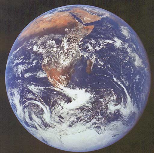
This image is in the public domain, from NASA, image #AS17-148-22727. Taken by US Navy Captain Ronald E. Evans, aboard Apollo 17 mission, on 7 December 1972. He used a 70mm Hasselblad camera. This view of Earth was taken 21 750 nautical miles from Earth and shows the west coast of Africa.
See also NASA's page on this photo [2], including confirmation that it is not protected by copyright. NASA notes: "View of the Earth as seen by the Apollo 17 crew traveling toward the Moon. This translunar coast photograph extends from the Mediterranean Sea area to the Antarctica South polar ice cap. This is the first time the Apollo trajectory made it possible to photograph the South polar ice cap. Note the heavy cloud cover in the Southern Hemisphere. Almost the entire coastline of Africa is clearly visible. The Arabian Peninsula can be seen at the Northeastern edge of Africa. The large island off the coast of Africa is the Malagasy Republic. The Asian mainland is on the horizon toward the Northeast."
| This file is in the public domain because it was created by NASA. NASA copyright policy states that "NASA material is not protected by copyright unless noted". (See Template:PD-USGov, NASA copyright policy page or JPL Image Use Policy.)
|
| Warnings:
|
File history
Click on a date/time to view the file as it appeared at that time.
| Date/Time | Thumbnail | Dimensions | User | Comment | |
|---|---|---|---|---|---|
| current | 12:38, 12 December 2020 | | 512 × 507 (45 KB) |
File usage
The following 2 pages link to this file: