Revision as of 10:13, 2 April 2011

|
File imported from Wikipedia Commons, see:
|
Summary
| Description
|
France relief location map.jpg
English: Blank physical map of France for geo-location purpose. Scale : 1:14,816,000 (accuracy : about 3,7 km) for the bathymetry
français : Carte physique vierge de la France destinée à la géolocalisation. Échelle : 1:14 816 000 (précision : environ 3,7 km) pour la bathymétrie
Equirectangular projection, WGS84 datum
- Central meridian: 002° 06' E
- True scale parallel: 46° 15' N
Geographic limits of the map :
- West : 005° 48' W
- East : 10° E
- North : 51° 30' N
- South : 41° N
|
| Date
|
{{MediaWiki:JulyTemplate:I18n month/form/⧼lang⧽ }} 2008(2008-07)
|
| Source
|
Own work
- Bathymetry : NGDC ETOPO2v2 (public domain) ;
- Topography : NASA Shuttle Radar Topography Mission (SRTM30 v.2) (public domain) ;
- Shoreline and additional data : World Data Base II (public domain).
|
| Author
|
Eric Gaba (Sting - fr:Sting)
|
Permission
(Reusing this file)
|
| Attribution and Share-Alike required
|
| Any use of this map can be made as long as you credit me (Eric Gaba – Wikimedia Commons user: Sting) as the author and distribute the copies and derivative works under the same license(s) that the one(s) stated below. A message with a reply address would also be greatly appreciated.
| |
| Other versions |
Template:DerivativeVersions
Template:Location
France relief location map.jpg
Equivalent administrative map (regions)
France location map.svg
from the german team (slight difference in the geographic limits of the map)
France location map-Departements.svg
Equivalent administrative map (départements)
France location map-Regions and departements.svg
Equivalent administrative map (regions and départements distinguished)
|
Template:Overlay
Template:Atelier graphique carte
Licensing:
Template:ImageNote
Template:Text fr
Template:Zh
Template:ImageNoteEnd
Click on a date/time to view the file as it appeared at that time.
| Date/Time | Thumbnail | Dimensions | User | Comment |
|---|
| current | 15:03, 12 December 2020 | 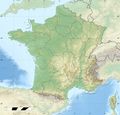 | 2,000 × 1,922 (814 KB) | Maintenance script (talk | contribs) | |
The following 3 pages link to this file:
This file contains additional information, probably added from the digital camera or scanner used to create or digitize it.
If the file has been modified from its original state, some details may not fully reflect the modified file.


![[1]](http://commons.wikimedia.org/w/index.php?title=File:France_relief_location_map.jpg&oldid=47997713)
