File:Hobet Mountaintop mine West Virginia 2009-06-02.jpg
From Wicri pool V1.31 Démo.Istex
No higher resolution available.
Hobet_Mountaintop_mine_West_Virginia_2009-06-02.jpg (720 × 480 pixels, file size: 155 KB, MIME type: image/jpeg)

Summary
| Description |
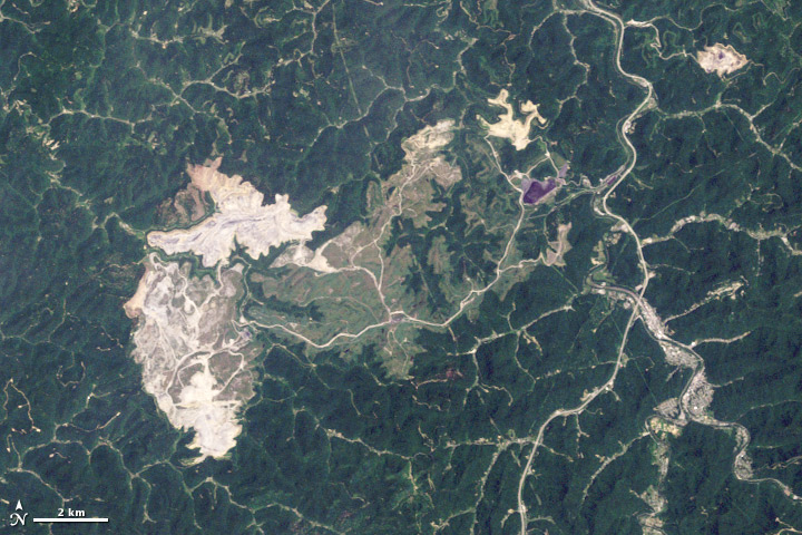
English: Below the densely forested slopes of southern West Virginia’s Appalachian Mountains is a layer cake of thin coal seams. To uncover this coal profitably, mining companies engineer large—sometimes very large—surface mines. This image of a surface mine in Boone County, West Virginia from 2009. Based on data from NASA’s Landsat 5 satellite, this natural-color (photo-like) image document the Hobet mine in 2009. The natural landscape of the area is dark green, forested mountains, creased by streams and indented by hollows. The active mining areas appear off-white, while areas being reclaimed with vegetation appear light green. A pipeline roughly bisects the images from north to south. The town of Madison, lower right, lies along the banks of the Coal River.
|
|---|---|
| Date |
2 {{MediaWiki:JuneTemplate:I18n month/form/⧼lang⧽ }} 2009 |
| Source |
http://earthobservatory.nasa.gov/Features/WorldOfChange/hobet.php?src=eoa-features |
| Author |
NASA |
| Permission (Reusing this file) |
See below. |
| Other versions |
|

![[1]](http://commons.wikimedia.org/w/index.php?title=File:Hobet_Mountaintop_mine_West_Virginia_2009-06-02.jpg&oldid=56695902)
Licensing
| This file is in the public domain because it was created by NASA. NASA copyright policy states that "NASA material is not protected by copyright unless noted". (See Template:PD-USGov, NASA copyright policy page or JPL Image Use Policy.)
|
| Warnings:
|
File history
Click on a date/time to view the file as it appeared at that time.
| Date/Time | Thumbnail | Dimensions | User | Comment | |
|---|---|---|---|---|---|
| current | 15:13, 12 December 2020 | | 720 × 480 (155 KB) | Maintenance script (talk | contribs) |
- You cannot overwrite this file.
File usage
The following 2 pages link to this file: