From Wicri pool V1.31 Démo.Istex

|
File imported from Wikipedia Commons, see:
|
Summary
Template:Location
| Description
|
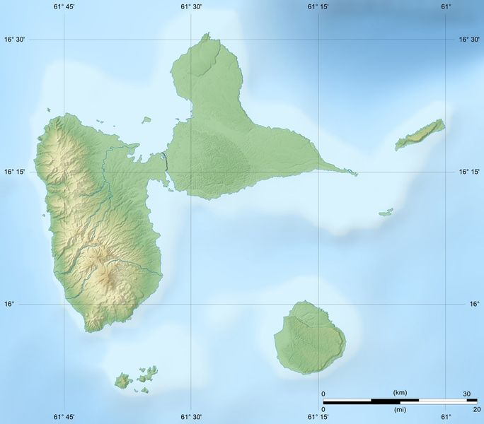
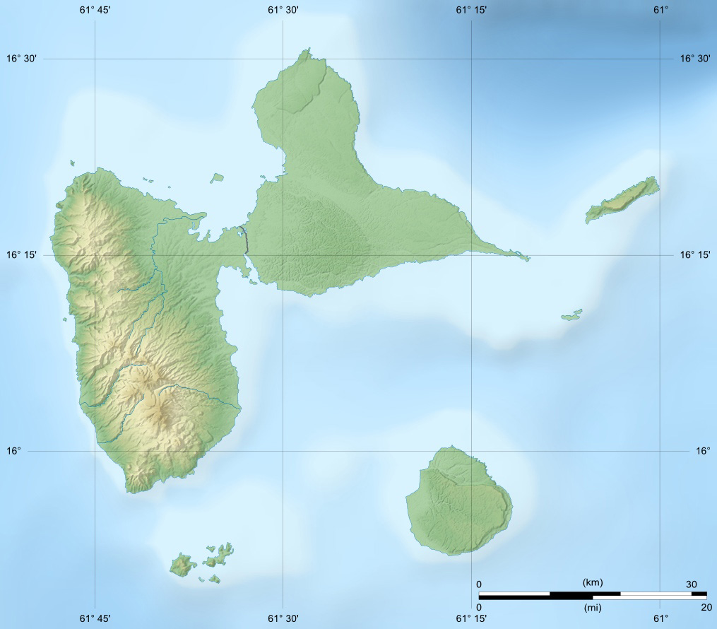
Guadeloupe department relief location map.jpg
English: Blank physical map of the region and department of Guadeloupe, France, for geo-location purpose, with arrondissements boundaries.
Template:Fr texte
Scales: 1:400,000 (precision: 100 m) for the topography; 1:7,412,000 (precision: 1,853 m) for the bathymetry
Equirectangular projection, WGS84 datum
- Standard meridian: 061° 24' W
- True scale parallel: 16° 10' 30” N
Geographic limits of the map:
- West: 061° 52' 30” W
- East: 060° 55' 30” W
- North: 16° 34' 30” N
- South: 15° 46' 30” N
|
| Date
|
{{MediaWiki:SeptemberTemplate:I18n month/form/⧼lang⧽ }} 2008(2008-09)
|
| Source
|
Own work
- Topography : NASA Shuttle Radar Topography Mission (SRTM3 v.2) (public domain) ;
- Bathymetry: NGDC ETOPO1 (public domain) ;
- Additional reference: Landsat 7 ETM+ imagery.
|
| Author
|
Eric Gaba (Sting - fr:Sting)
|
Permission
(Reusing this file)
|
| Attribution and Share-Alike required
|
| Any use of this map can be made as long as you credit me (Eric Gaba – Wikimedia Commons user: Sting) as the author and distribute the copies and derivative works under the same license(s) that the one(s) stated below. A message with a reply address would also be greatly appreciated.
| |
| Other versions |
Equivalent administrative map
|
Licensing:
| I, the copyright holder of this work, hereby publish it under the following licenses:cellspacing="8" cellpadding="0" style="width:100%; clear:both; text-align:center; margin:0.5em auto; background-color:#f9f9f9; border:2px solid #e0e0e0; direction: ltr;" class="layouttemplate"
Template:License migration redundantYou may select the license of your choice.
|
File history
Click on a date/time to view the file as it appeared at that time.
| Date/Time | Thumbnail | Dimensions | User | Comment |
|---|
| current | 15:21, 12 December 2020 |  | 1,015 × 890 (169 KB) | Maintenance script (talk | contribs) | |
- You cannot overwrite this file.
File usage
The following 2 pages link to this file:
This file contains additional information, probably added from the digital camera or scanner used to create or digitize it.
If the file has been modified from its original state, some details may not fully reflect the modified file.


