![]() Attention, suite à une faille de sécurité, les liens vers les serveurs d'exploration sont désactivés.
Attention, suite à une faille de sécurité, les liens vers les serveurs d'exploration sont désactivés.
-
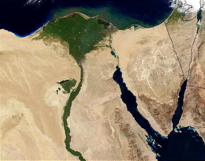
Fichier:Nile River and delta from orbit.jpg
De Wicri Eau
Pas de plus haute résolution disponible.
Nile_River_and_delta_from_orbit.jpg (700 × 550 pixels, taille du fichier : 85 Kio, type MIME : image/jpeg)
Ce fichier provient de un dépôt partagé. Il peut être utilisé par d'autres projets. Sa description sur sa page de description est affichée ci-dessous.


![[1]](http://commons.wikimedia.org/w/index.php?title=File:Nile_River_and_delta_from_orbit.jpg&oldid=27910789)
| Description |
Nile River and delta from orbit Description: The Nile River and delta as seen from space by the MODIS sensor on the Terra satellite.
|
|---|---|
| Date |
5 {{MediaWiki:FebruaryTemplate:I18n month/form/⧼lang⧽ }} 2003 |
| Source | |
| Author |
Jacques Descloitres, MODIS Rapid Response Team, NASA/GSFC |
| Permission (Reusing this file) |
See below. |
![[2]](http://visibleearth.nasa.gov/data/ev245/ev24588_Egypt.A2003036.0840.1km.jpg)
Licence
| This file is in the public domain because it was created by NASA. NASA copyright policy states that "NASA material is not protected by copyright unless noted". (See Template:PD-USGov, NASA copyright policy page or JPL Image Use Policy.)
|
| Warnings:
|
Historique du fichier
Cliquer sur une date et heure pour voir le fichier tel qu'il était à ce moment-là.
| Date et heure | Vignette | Dimensions | Utilisateur | Commentaire | |
|---|---|---|---|---|---|
| actuel | 12 décembre 2020 à 13:20 | | 700 × 550 (85 Kio) |
Utilisation du fichier
Les 3 pages suivantes utilisent ce fichier :