
No higher resolution available.
This file is from a shared repository and may be used by other projects.
The description on its file description page there is shown below.

|
File imported from Wikipedia Commons, see:
|
This is a map of the Ohio River Watershed. I, Karl Musser, created it based on USGS data.
| I, the copyright holder of this work, hereby publish it under the following license:cellspacing="8" cellpadding="0" style="width:100%; clear:both; text-align:center; margin:0.5em auto; background-color:#f9f9f9; border:2px solid #e0e0e0; direction: ltr;" class="layouttemplate"
|
File history
Click on a date/time to view the file as it appeared at that time.
| Date/Time | Thumbnail | Dimensions | User | Comment |
|---|
| current | 13:06, 12 December 2020 | 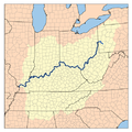 | 500 × 500 (267 KB) | | |
File usage
The following page links to this file:
This file contains additional information, probably added from the digital camera or scanner used to create or digitize it.
If the file has been modified from its original state, some details may not fully reflect the modified file.

![[1]](http://commons.wikimedia.org/w/index.php?title=File:Ohiorivermap.png&oldid=4466994)